Enregistrez gratuitement cette image
en 800 pixels pour usage maquette
(click droit, Enregistrer l'image sous...)
|
|
Réf : T02776
Thème :
Terre vue de l'espace - Iles - Récifs (286 images)
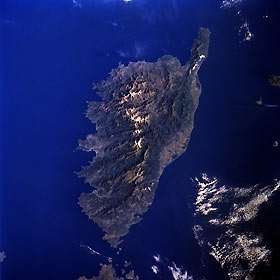
Titre : Corsica, France May 1997
Description : (La description de cette image n'existe qu'en anglais)
Corsica, France May 1997 Corsica, annexed by France in 1768, is a mountainous island with a rocky coastline that is severely indented along the west side of the island. Snow-capped mountain ridges (lighter colored areas), exceeding 7000 feet (2134 meters) in elevation help to identify a north, northwest to south, southeast alignment of the higher elevations that extend almost the entire length (118 miles-190 km) of the island. A narrow coastal plain, including lagoons and swamps, is visible along part of the east coast of the island. Less than 5 percent of the land area is suitable for the commercial cultivation of crops. Tourism has surpassed fishing as the leading economic activity for Corsica. The Strait of Bonifacio separates Corsica from the Italian island of Sardinia to the south (top center).
|
|

