Enregistrez gratuitement cette image
en 800 pixels pour usage maquette
(click droit, Enregistrer l'image sous...)
|
|
Réf : S14379
Thème :
Terre vue de l'espace - Montagnes - Collines - Neige - Glace (539 images)
Titre : Pyrenees Mtns., Spain
Description : (La description de cette image n'existe qu'en anglais)
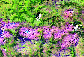
This image, acquired on August 1, 2000, covers an area of 57 by 29 km and covers part of the central Pyrenees in Spain. The Pyrenees in southwestern Europe extend for about 435 kilometers (about 270 miles) from the Bay of Biscay to the Mediterranean Sea, separating the Iberian Peninsula from the rest of Europe. The Pyrenees form most of the boundary between France and Spain, and encompass the tiny principality of Andorra. Approximately two-thirds of the mountains lie in Spain. The central Pyrenees extend to the Collines du Perche and contain the highest peaks of the system, including Pico de Aneto, the highest at 3,404 meters (11,168 feet). Instrument bands 4, 3 and 2 were displayed in red, green and blue. In this combination, snow is blue, vegetation is green, bare rocks are pink and dark blue, and clouds are white.
|
|

