Enregistrez gratuitement cette image
en 800 pixels pour usage maquette
(click droit, Enregistrer l'image sous...)
|
|
Réf : T01141
Thème :
Terre vue de l'espace - Fleuves - Rivières - Lacs (517 images)
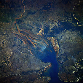
Titre : Betsiboka River Delta, Madagascar June 1983
Description : (La description de cette image n'existe qu'en anglais)
Dramatic evidence of the catastrophic erosion of northwestern Madagascar is revealed in this near-vertical, June 1983 photograph of the rapidly expanding Betsiboka River Delta. The removal of the native forest for cultivation and pastureland during the past 50 years has led to massive annual soil losses approaching 112 tons per acre (250 metric tons per hectare) in some regions of the island, the largest amount recorded anywhere in the world. The photograph provides convincing evidence of the result of this process, as the effects of water erosion are seen throughout the 1544-square-mile (4000-square-kilometer) land surface area of the photograph. The delta continues to build toward the mouth of Bombetoka Bay, which enters the Mozambique Channel.
|
|

