Enregistrez gratuitement cette image
en 800 pixels pour usage maquette
(click droit, Enregistrer l'image sous...)
|
|
Réf : T01245
Thème :
Terre vue de l'espace - Forêts (124 images)
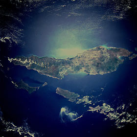
Titre : Timor Island, Indonesia November 1989
Description : (La description de cette image n'existe qu'en anglais)
Timor Island, one of the larger islands of the Lesser Sunda Islands, is located between the Savu Sea to the northwest and the Timor Sea to the southeast. The western half of the island, under Dutch control until 1949, and the eastern half, a Portuguese province until 1975, are now united as a province of Indonesia. Timor Island is approximately 300 miles (480 kilometers) long and 10 to 65 miles (16 to 105 kilometers) wide. Timor and the north-northwest arc of islands around the eastern end of the Banda Sea, all volcanic in origin, are in an unstable region of the world because of the intersection of three major tectonic plates northeast near Irian Jaya, Indonesia. Although it is located in the tropics, Timor Island has a definite dry season during the winter. Large forested volcanic mountains exist; however, much of the landscape lacks dense stands of tropical forest or jungle. Major cash crops include coffee, sandalwood, and copra.
|
|

